|
HISTORY
Here is a 96-page documentary description of the historic neighborhood – including descriptions of each individual structure.
***
In the 18th and early 19th centuries, the areas now known as Brooklyn and Glenwood were part of the substantial Wake County landholdings of planter Joel Lane. Lane, whose relocated house now sits adjacent to Boylan Heights, sold the state the land on which the new capital of Raleigh was laid out in 1791.
During this period the area was known as Will's Forest. According to Elizabeth Cuthberson Waugh, writing in North Carolina's Capital: Raleigh, a slave ship wrecked off North Carolina coast about 1760. Six of the slaves survived and were brought inland to Raleigh, where four later died. Two men, Will and Mark, were cared for by Colonel Lane, and were not claimed as slaves. Lane supplied their needs and built them a cabin on a corner of his property, where they lived until their deaths. Because of Will's charm, the area they inhabited became known as "Will's Forest. "
In 1842, Margaret Lane Mordecai (daughter of Moses and Ann Lane Mordecai, builders of the Mordecai House), married John Devereux, Jr. Devereux inherited a substantial fortune from his grandfather in 1844. He bought the family plantation Runiroi Meadows in Bertie County from his father in 1846 and probably also built a fine Greek Revival house about that time on the Will's Forest tract that Margaret had inherited. The Devereuxs spent winters at Runiroi Meadows and summered in the house called Will's Forest. Maps from the 1880s show a complex of house and outbuildings between what are now Glenwood Avenue and West Street, probably between Tilden and Devereux Streets.
During the Civil War, John Devereux was the Chief Quartermaster for the State of North Carolina. He was responsible for supplying North Carolina troops with provisions, a duty that included running the state's very successful blockade-running business. The Devereuxs lived at Will's Forest full-time. Confederate fortifications for Raleigh ran along the top of the ridge behind what are now Cleveland Street and Wills Forest Street, curving around to following St. Mary's Street to the south. As Sherman's troops approached Raleigh at the end of the war, Devereux was a member of the delegation that surrendered the city. Federal troops camped in the grove around Devereux Branch until August of 1865.
 In the decades after the war, portions of the 150 acre tract surrounding the house were given or sold to the Devereux daughters and their husbands. Daughter Ellen had married prominent attorney John Hinsdale and they built a house on a tract at the northwest corner of what are now Peace Street and Glenwood Avenue, which they called Glenwood. Daughter Mary Livingstone and her husband Arthur Winslow received another tract, which included the land from Peace to Wills Forest and Boylan Avenue to Glenwood, minus the Hinsdale parcel that reached from Peace to Devereux Street. By 1887, the Winslow tract had already been subdivided into the streets that we see today.
The Devereuxs and their family were not the only residents of the area in the late 1800s. To the west was the large Cameron plantation, and between them was the Brooklyn community. It's not clear where the name Brooklyn came from, but a small parcel of land was acquired from the Devereuxs in 1876 ("in what is known and called the Wills Hill settlement"), and by 1881 maps show the Brooklyn Methodist Episcopal Church north of Brooklyn Street and east of Clay Street.
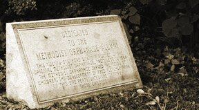
At the end of the century, a group of Methodists led by Rev. John Wesley Jenkins pushed for the establishment of a Methodist orphanage and home for superannuated preachers in Raleigh. Forty-five acres along St. Mary's Street were purchased from Mrs. John Devereux in 1899, adjacent to the Brooklyn Church. The Methodists also purchased three and three-quarters acres-at the corner of Boylan Avenue and Devereux Streets. The orphanage opened in 1900, with Rev. Jenkins as superintendent. A brick home was constructed for the orphanage superintendent, which was later converted into a dormitory and renamed the Borden Building. Rev. Jenkins died on July 4, 1906. A new frame church constructed at the corner of Boylan and Devereux Streets in 1907 was named in his honor. The church burned in 1914, and the present brick sanctuary was built on the site in 1916.
In May of 1905, James H. Pou, Albert Murray and William J. Andrews incorporated the Glenwood Land Company. A month later, they purchased the former Winslow subdivision, as well as the reminder of the Devereux lands, about 67.2 acres. Almost immediately, the land was plotted and prepared for sale. The first parcel, called the Brooklyn Hill Subdivision, was plotted in July of 1905, and included the area between Peace and Devereux Streets, Boylan Avenue and Gaston Street (then called Brooklyn Road). In June of 1906 the first plot of Glenwood was registered. It included the old Winslow subdivision, together with the Devereux land between Peace Street and Bushy Branch (where Wade Avenue is today). For the first time, the extension of Saunders Street shows up on maps as Glenwood Avenue, apparently in honor of the Hinsdale house, with the streetcar line extended down the middle. At some point during this period, the Wills Forest House was torn down.
Climbing on the development bandwagon, the Hinsdales in June of 1907 filed a subdivision of their Glenwood property, reserving for themselves the lot at the comer of Peace and Glenwood Avenue.
In an apparent attempt to close out their development, the Glenwood Land Company held an auction of the remaining lots in June of 1908, selling more than 125 of them at prices from $175 to $600 each. They also sold all of the lots on the west side of Glenwood to the trustees of the Methodist Orphanage. A final subdivision plot for the area was filed in 1909.
Until it burned in 1914, students from the area attended the Brooklyn School on Boylan Avenue, where the vacant lot is located across from McDonald's. The School Board had purchased lots from John Hinsdale in 19l0. In 1914 it built a new school with five classrooms, naming it after Dr. Richard Lewis, a former school board member. Additional classrooms were added in 1917, and an auditorium in 1940. Lewis School closed about 1955, and in the 1960s the building became the administrative offices of the Wake County Schools.
Other government buildings were constructed in the area, including the State Laboratory of Hygiene, called the "Pasteur Institute," at the corner of Dale and Jefferson Streets, about 1917. Around 1927, the City of Raleigh built a small fire station, Engine Company #4, at 505 Jefferson. It remained in use until the early 1960s.
Commercial and institutional buildings were scattered through the neighborhood. The Glenwood Pharmacy at 700 Glenwood was built about 1911, and the Pure Food Grocery (later Greene's Grocery) at 1120 Glenwood around 1941. The Glenwood Grocery at 719 Devereux was constructed about 1915. The commercial building on the opposite corner at 720 Devereux dates from about 1936. The present St. John Metropolitan Church was built about 1955 for the First Church of the Assemblies of God. The Hinsdale Apartments at the corner of Hinsdale and Glenwood date from about 1936.
The trolley lines that ran up Glenwood Avenue to Bloomsbury Park (now the Carolina Country Club) were replaced in 1933 by bus service. In the early 1980s, the Methodists closed the orphanage and sold off the orphanage property, including 8 acres which were purchased by the City of Raleigh for the construction of Fletcher Park.
David Black
April 1997
###
Please report broken links or other concerns.
updated 11 March 2009,